


Kolida K58 Plus Farlink Protocol Imu 1598 Channels Landscaping Surveying Instrument Dgps Gps Gnss Rtk Kolida K7
- Pre-Order Available (Estimated ±15 Day Delivery)
- 7 day unit replacement guarantee(Video Unboxing Required)
- Including shipping costs, sent by Supplyinx.com
- Pick up at a supplyinx.com collection point is possible
- 24/7Customer service
Description

Full function radio station.
WIFI data link.
4G full network connectivity.
Bluetooth data link.
|
|
product name
|
kolida tianxing
|
|
|
Measurement Performance |
Signal tracking |
BDS-2:B1I, B2I, B3I; BDS-3:B1I, B3I, B1C, B2a, B2b
|
|
|
|
|
GPS:L1C/A,L2P,L2C,L5,L1C*
|
|
|
|
|
GLONASS: G1, G2, G3*; SBAS: L1C/A,L5*
|
|
|
|
|
Galileo: E1,E5b,E5a,E5 AltBoc*,E6c*
|
|
|
|
|
QZSS: L1, L2C, L5; IRNSS: L5*
|
|
|
|
|
1598 channels
|
|
|
|
GNSS features |
Positioning output frequency 1Hz to 20Hz; initialisation time less than 10 seconds
|
|
|
|
|
Initialisation reliability >99.99%
|
|
|
|
|
Full constellation reception technology, which can fully support signals from all current GNSS constellations
|
|
|
|
|
Highly reliable carrier tracking technology, which greatly improves carrier accuracy and provides users with high quality raw
observation data |
|
|
|
|
Intelligent dynamic sensitivity positioning technology, adapting to various environmental changes, adapting to harsher and more
distant positioning environments |
|
|
|
|
Highly accurate positioning processing engine
|
|
|
Positioning Accuracy |
Code differential GNSS positioning
|
Horizontal: 0.25 m + 1 ppm RMS
|
|
|
|
|
Vertical: 0.50 m + 1 ppm RMS
|
|
|
|
Static CNSS measurements
|
Plane: ± (2.5mm + 0.5 x 10⁻⁶D); Elevation: ± (5mm + 0.5 x 10⁻⁶D); (D is the length of the baseline being measured, in mm)
|
|
|
|
Real-time dynamic measurement
|
Plane: ± (8 mm + 1 x 10⁻⁶D); Elevation: ± (15 mm + 1 x 10⁻⁶D) (D is the length of the measured baseline in mm)
|
|
|
Operating Systems/User Interaction |
Operating system: Linux
|
|
|
|
|
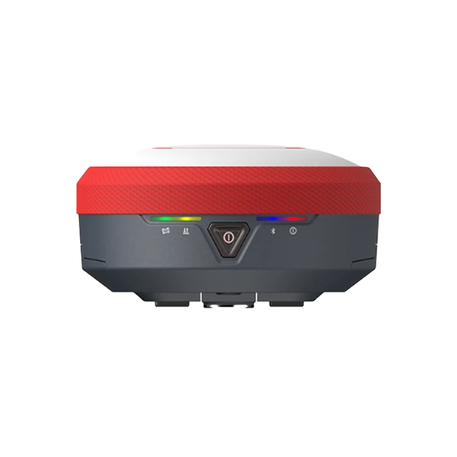
Keypad: single button
|
|
|
|
|
Indicator lights: Four indicator lights. Satellite light, differential signal light, Bluetooth light, power light
|
|
|
|
|
Web interaction: support WI-FI and USB mode to access the receiver built-in Web management page, monitor the host status, free
configuration of the host, etc. |
|
|
|
|
Voice: iVoice intelligent voice technology, intelligent status announcement, voice operation prompt; default support for Chinese,
English, Korean, Russian, Portuguese, Spanish, Turkish |
|
|
|
|
Secondary development: provide secondary development package, open OpenSIC observation data format and interaction interface
definition for secondary development |
|
|
|
|
Data cloud service: powerful cloud service management platform, allowing remote management and configuration of equipment, viewing
progress, managing jobs, etc. Can use Qualitec servers or build your own servers |
|
|
|
Hardware |
Size: 156mm*78mm (diameter, height)
|
|
|
|
|
Weight: 1.3kg (with battery)
|
|
|
|
|
Material: magnesium alloy
|
|
|
|
|
Operating temperature: -30 °C to +70 °C; storage temperature: -40 °C to +80 °C
|
|
|
|
|
Humidity resistant to 100% condensation
|
|
|
|
|
Protection class: IP68, waterproof: 1m immersion, dustproof: completely protected against dust ingress
|
|
|
|
|
Resistant to a 2 m drop with a pole
|
|
|
|
Electrical |
Power supply: 6~28V wide voltage DC design with overvoltage protection
|
|
|
|
|
Battery: detachable dual battery design, support hot-swappable, voltage: 7.4V, 3400mAh/block
|
|
|
|
|
Power solution: Mobile station mode, typical endurance time >20 hours at full charge, support battery power supply, rechargeable
battery power supply |
|
|
|
Communication |
I/O ports |
5 pole LEMO external power connector + RS232
|
|
|
|
|
Type-C interface for power supply, data transmission
|
|
|
|
|
One radio antenna port
|
|
|
|
|
Micro SIM card slot (medium card)
|
|
|
|
Radio modems |
Built-in transceiver radio, typical operating distance 10km; support radio relay, network routing function.
|
|
|
|
|
Operating frequency 410-470MHz; communication protocols: Farlink,TrimTalk450S,ZHD,SOUTH,HUACE,Satel
|
|
|
|
4G all-access |
Intelligent PPP dialing technology based on Linux platform, automatic real-time dialing, continuous online during work; built-in
network antenna |
|
|
|
|
Equipped with a 4G tell-tale network communication module, compatible with various CORS systems access
|
|
|
|
Bluetooth |
Bluetooth 3.0/4.1.
|
|
|
|
|
Bluetooth 2.1+EDR standard
|
|
|
|
NFC wireless communication |
NFC wireless communication technology, Bluetooth automatic pairing can be achieved by touching the handbook and the main unit
(requires handbook also equipped with NFC wireless communication module) |
|
|
|
eSIM (optional) |
The eSIM chip can be embedded in the handbook to provide network resources in real time to ensure continuous online network
operation of the host computer, supporting external card solutions |
|
|
WIFI |
Standard
|
802.11b/g/n standards
|
|
|
|
WIFI Hotspot |
With WIFI hotspot function, any intelligent terminal can be connected to the receiver for rich personalization of the receiver
functions |
|
|
|
|
Data transfer between industrial handbooks, intelligent terminals and other data collectors and receivers via WIFI
|
|
|
|
WIFI data chain
|
Receiver can be connected to WIFI for differential data broadcast or reception via WIFI
|
|
|
Data Storage/Transfer |
Data storage |
8G internal solid state memory
|
|
|
|
|
Auto-cycle storage (automatically delete the earliest data when there is not enough storage space)
|
|
|
|
|
Supports external USB memory for data storage
|
|
|
|
|
Rich sampling interval, up to 20Hz raw observation data acquisition
|
|
|
|
Data transfer |
One-button intelligent copy of static data directly from the host computer via external USB memory
|
|
|
|
|
Plug-and-play USB data transfer method
|
|
|
|
|
Supports USB, FTP download, HTTP data transfer
|
|
|
|
Data format |
Static data formats: Southern STH, Rinex 2.01 and Rinex 3.02 and many more
|
|
|
|
|
Differential data formats: RTCM3.0, RTCM3.2
|
|
|
|
|
GPS output data formats: NMEA 0183, PJK planar coordinates, binary codes
|
|
|
|
|
Network mode support: VRS, FKP, MAC, NTRIP protocol support
|
|
|
Sensors |
Inertial tilt measurement |
Built-in IMU inertial measurement sensor, supports inertial tilt measurement function, automatically corrects coordinates
according to the tilt direction and angle of the centering rod |
|
|
|
|
Tilt angle: 0°~60°; IMU update rate: 200HZ
|
|
|
|
Tilt compensation accuracy
|
1.8 m pole; RMS: 8 mm + 0.7 mm/°tilt
|
|
|
|
Temperature sensors |
Built-in multiple temperature sensors, using intelligent frequency conversion temperature control technology, real-time monitoring
and adjustment of the host temperature |
|


VR


and Credit Card.
2. How can you guarantee the safety of my funds?
Trust is always a big problem for international trade, we believe good business
credit and reputation is the most important for businessman. We recommend Trade Assurance ser-vice by Alibaba Group. We wont get the fund unless you get the product and confirm the payment.
3. What Countries do you ship to?
We ships goods to almost all countries by express, air or sea. And we willinform you if we cant ship to your country.
4. Are your products in stock?
Most items are usually in stock. It all depends on promotions we run, demand at manufac-turers and suppliers. Most delivery will be made within 3 working days after payment con-firmed.
5. Do you sell used surveying equipment?
We do not sell any used equipment. Everything we sell is brand new. For some equipment we may need to test or check the language before delivery.
6. Do you have other items that are not displayed on your website?
Yes, we have other items that we do not display on our website.
Please contact us and let us know what you are looking for as long as its surveying related.
Related products


NT-023 Multi-functional Double Laser Red beam surveying instrument Electronic Theodolite


Foif RTS102R10 2″ Accuracy Total Station Measuring Surveying Instrument, 1000m Prism-free


Reviews
There are no reviews yet.