
The best discounts this week
Every week you can find the best discounts here.


2 units New G1Gnss Gps Rtk Surveying Instrument

1598 channels South G9 Gps Surveying Instrument South gnss rtk GPS RTK


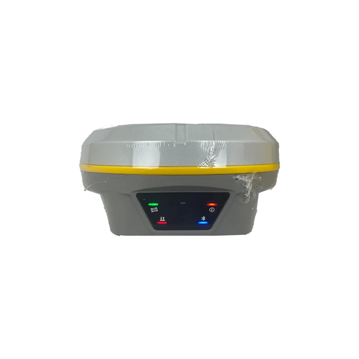


2025 SOUTH G3 GPS GNSS RTK Surveying High-precision Land Surveying Equipment,with Farlink Professional Instrument
- Delivered today (order Mon-Fri before 12:00, delivery between 17:00 and 22:00)
- Including shipping costs, sent by Supplyinx.com
- Pick up at a supplyinx.com collection point is possible
- 30 days to change your mind and free returns
- Day and night customer service
Description
2025 SOUTH G3 GPS GNSS RTK Surveying Equipment
Peralatan Survei Lahan Presisi Tinggi dengan Teknologi RTK dan Sistem Farlink Profesional
(Solusi Lengkap dan Handal untuk Survei Topografi dan Pemetaan Modern)
Deskripsi Produk
2025 SOUTH G3 adalah perangkat survei GNSS RTK generasi terbaru yang dirancang untuk memberikan tingkat presisi dan keandalan tinggi dalam berbagai aplikasi pengukuran lahan dan topografi. Dengan dukungan teknologi RTK (Real-Time Kinematic), alat ini mampu menghasilkan data posisi dengan akurasi hingga sentimeter secara real-time, yang sangat penting untuk proyek konstruksi, pemetaan cadastral, dan pengelolaan aset infrastruktur. Sistem Farlink profesional yang terintegrasi memastikan koneksi data yang stabil dan efisien antara unit base dan rover, sehingga memudahkan pengoperasian di lapangan dengan minim gangguan. Desain perangkat yang ergonomis dan tahan cuaca membuat SOUTH G3 sangat cocok untuk digunakan dalam berbagai kondisi lingkungan, baik di medan terbuka maupun di area yang menantang.
Fitur Utama
-
Teknologi RTK untuk pengukuran posisi real-time dengan akurasi sentimeter
-
Dukungan multi-konstelasi satelit: GPS, GLONASS, Galileo, BeiDou
-
Sistem komunikasi Farlink profesional untuk transfer data yang stabil dan cepat
-
Desain tahan air dan debu sesuai standar IP67, ideal untuk penggunaan lapangan berat
-
Baterai berkapasitas besar yang memungkinkan penggunaan selama jam kerja penuh tanpa henti
-
Antarmuka pengguna intuitif dengan layar warna dan kontrol sentuh
-
Kompatibel dengan berbagai perangkat lunak survei dan GIS modern
Aplikasi
-
Survei topografi dan pemetaan lahan presisi tinggi
-
Proyek konstruksi jalan, jembatan, dan infrastruktur teknik sipil
-
Pemetaan cadastral dan penentuan batas tanah dengan akurasi tinggi
-
Monitoring deformasi dan pemeliharaan aset infrastruktur
-
Pengumpulan data GIS untuk manajemen lingkungan dan perkotaan
Ringkasan
2025 SOUTH G3 GPS GNSS RTK Surveying Equipment merupakan solusi lengkap dan canggih yang dirancang khusus untuk para profesional survei dan teknik sipil yang menuntut akurasi tinggi dan keandalan maksimal dalam setiap pengukuran di lapangan. Dengan teknologi RTK mutakhir dan sistem komunikasi Farlink yang handal, perangkat ini tidak hanya memberikan data posisi yang sangat presisi secara real-time, tetapi juga memastikan kelancaran komunikasi antar perangkat dalam kondisi medan yang berat sekalipun. Dirancang dengan bodi tahan lama dan fitur baterai yang mendukung operasi sepanjang hari, SOUTH G3 sangat ideal digunakan dalam berbagai proyek survei, konstruksi, dan pemetaan modern yang memerlukan efisiensi tinggi serta hasil yang konsisten.

|
GNSS Features
|
Channels
|
1598
|
|
|
GPS
|
L1, L1C, L2C, L2P, L5
|
|
|
GLONASS
|
L1C/A, L1P, L2C/A, L2P, L3
|
|
|
BDS
|
BDS-2: B1I, B2I, B3I
BDS-3: B1I, B3I, B1C, B2a, B2b* |
|
|
GALILEO
|
E1, E5A, E5B, E6C, AltBOC*
|
|
|
SBAS (WASS, MSAS, EGNOS and GAGAN)
|
L1C/A
|
|
|
IRNSS
|
L5*
|
|
|
QZSS
|
L1, L2C, L5*
|
|
|
MSS L-Band
|
BDS-PPP
|
|
|
Positioning output rate
|
1Hz~20Hz
|
|
|
Initialization time
|
< 10s
|
|
|
Initialization reliability
|
> 99.99%
|
|
Positioning Precision*
|
Code differential GNSS positioning
|
Horizontal: 0.25 m + 1 ppm RMS
Vertical: 0.50 m + 1 ppm RMS |
|
|
Static(long observations)
|
Horizontal: 2.5 mm + 1 ppm RMS
Vertical: 3 mm + 0.4 ppm RMS |
|
|
Static
|
Horizontal: 2.5 mm + 0.5 ppm RMS
Vertical: 3.5 mm + 0.5 ppm RMS |
|
|
Rapid static
|
Horizontal: 2.5 mm + 0.5 ppm RMS
Vertical: 5 mm + 0.5 ppm RMS |
|
|
PPK
|
Horizontal: 3 mm + 1 ppm RMS
Vertical: 5 mm + 1 ppm RMS |
|
|
RTK(UHF)
|
Horizontal: 8 mm + 1 ppm RMS
Vertical: 15 mm + 1 ppm RMS |
|
|
RTK(NTRIP)
|
Horizontal: 8 mm + 0.5 ppm RMS
Vertical: 15 mm + 0.5 ppm RMS |
|
|
RTK initialization time
|
2 ~ 8s
|
|
|
SBAS positioning
|
Typically < 5m 3DRMS
|
|
|
BANDA-L
|
Horizontal: 5-10cm (5-30min)
Vertical: 10-30cm (5-30min) |
|
|
IMU
|
Less than 10mm + 0.7 mm/° tilt to 30°
|
|
|
IMU tilt angle
|
0° ~ 60°
|
|
Hardware Performance
|
Dimension
|
130.5mm(φ) × 84mm(H)
|
|
|
Weight
|
850g (battery included)
|
|
|
Material
|
Magnesium aluminum alloy shell
|
|
|
Operating temperature
|
-25℃ ~ +65℃
|
|
|
Storage temperature
|
-35℃ ~ +80℃
|
|
|
Humidity
|
100% Non-condensing
|
|
|
Waterproof/Dustproof
|
IP68 standard, protected from long time immersion to depth of 1m IP68 standard, fully protected against blowing dust
|
|
|
Shock/Vibration
|
Withstand 2 meters pole drop onto the cement ground naturally
MIL-STD 810G |
|
|
Power supply
|
6-28V DC, overvoltage protection
|
|
|
Battery
|
Inbuilt 6800mAh rechargeable, removable Lithium-ion battery
|
|
|
Battery life
|
Single battery: 16h (static mode), 8h (Base + UHF), 12h (Rover + UHF), 15h (Rover + Bluetooth)
|
|
Communications
|
I/O Port
|
5PIN LEMO external power port + Rs232
Type-C interface (charge + OTG + Ethernet) 1 UHF antenna interface SIM card slot (Micro SIM) |
|
|
Internal UHF
|
2W radio, receive and transmit, radio router and radio repeater
|
|
|
Frequency range
|
410 – 470MHz
|
|
|
Communication protocol
|
Farlink, Trimtalk450s, SOUTH, SOUTH+, SOUTHx, HUACE, Hi-target, Satel
|
|
|
Communication range
|
Typically 8km with Farlink protocol
|
|
|
Cellular mobile network
|
4G cellular module standard
|
|
|
Bluetooth
|
Bluetooth 3.0/4.1 standard, Bluetooth 2.1 + EDR
|
|
|
NFC Communication
|
Realizing close range (shorter than 10cm) automatic pair between receiver and controller (controller requires NFC wireless
communication module else) |
|
WIFI
|
Modem
|
802.11 b/g standard
|
|
|
WIFI hotspot
|
Receiver broadcasts its hotspot form web UI accessing with any mobile terminals
|
|
|
WIFI datalink
|
Receiver can transmit and receive correction data stream via WiFi datalink
|
|
Data Storage/Transmission
|
Storage
|
8GB SSD internal storage standard, extendable up to 64GB
Automatic cycle storage (The earliest data files will be removed automatically while the memory is not enough) Support external USB storage The customizable sample interval is up to 20Hz |
|
|
Data transmission
|
Plug and play mode of USB data transmission
Supports FTP/HTTP data download |
|
|
Data format
|
Static data format: STH, Rinex2.01, Rinex3.02 and etc.
Differential data format: RTCM 2.1, RTCM 2.3, RTCM 3.0, RTCM 3.1, RTCM 3.2 Output format: ASIC (NMEA-0813), Binary code (SOUTH Binary) Network model support: VRS, FKP, MAC, fully support NTRIP protocol |
|
Sensors
|
Electronic bubble
|
Controller software can display electronic bubble, checking leveling status of the carbon pole in real-time
|
|
|
IMU
|
Built-in IMU module, calibration-free and immue to magnetic interference
|
|
|
Thermometer
|
Built-in thermometer sensor, adopting intelligent temperature control technology, monitoring and adjusting the receiver
temperature |
|
User Interaction
|
Operating system
|
Linux
|
|
|
Buttons
|
Single button
|
|
|
Indicators
|
5 LED indicators
|
|
|
Web interaction
|
With the access of the internal web interface management via WiFi or USB connection, users are able to monitor the receiver status
and change the configurations freely |
|
|
Voice guidance
|
It provides status and operation voice guidance, and supports Chinese/English/Korean/Spanish/Portuguese/Russian/Turkish
|
|
|
Secondary development
|
Provides secondary development package, and opens the OpenSIC observation data format and interaction interface definition
|
|
|
Cloud service
|
The powerful cloud platform provides online services like remote manage, firmware update, online register and etc.
|


Related products


JUWEI17-100 Wide dovetail groove astronomical telescopes harmonic equatorial instrument compatible with theodolites


Reviews
There are no reviews yet.