


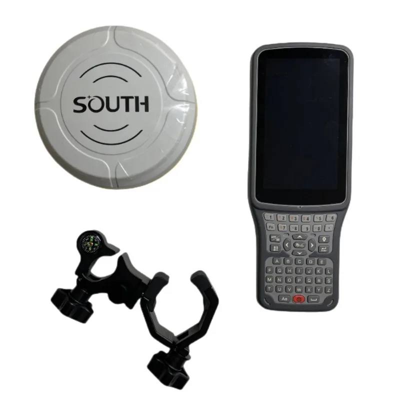
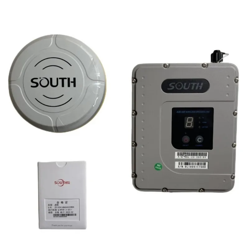


South G3 GPS Land Surveying Instrument, Rover and Base, Language Switchable, Integrated Transceiver Farlink Radio Protocol
- Pre-Order Available (Estimated ±15 Day Delivery)
- 7 day unit replacement guarantee(Video Unboxing Required)
- Including shipping costs, sent by Supplyinx.com
- Pick up at a supplyinx.com collection point is possible
- 24/7Customer service
Description
South G3 GPS Land Surveying Instrument – Rover and Base, Language Switchable, Integrated Transceiver Farlink Radio Protocol
South G3 GPS Land Surveying Instrument dengan Rover and Base, pemilihan bahasa, dan integrasi transceiver Farlink Radio Protocol, memberikan solusi pengukuran presisi tinggi untuk aplikasi survei tanah dan pemetaan geospasial.
Penjelasan Singkat
South G3 GPS Land Surveying Instrument adalah sistem GPS untuk survei tanah yang terdiri dari Rover dan Base station untuk pengukuran presisi tinggi. Dilengkapi dengan transceiver Farlink Radio Protocol, alat ini memungkinkan komunikasi data yang stabil dan jarak jauh. Dengan kemampuan pemilihan bahasa, instrumen ini sangat cocok untuk digunakan di berbagai negara dengan berbagai bahasa. Sistem ini ideal untuk aplikasi survei geospasial, pemetaan tanah, dan konstruksi.
Deskripsi Produk
South G3 GPS Land Surveying Instrument adalah sistem GPS RTK yang menggabungkan Rover dan Base untuk memberikan akurasi tinggi dalam pengukuran posisi. Sistem ini dilengkapi dengan transceiver Farlink Radio Protocol untuk komunikasi data yang lebih jauh dan lebih stabil. Selain itu, sistem ini menawarkan pemilihan bahasa, memudahkan penggunaan instrumen ini di seluruh dunia. South G3 ideal untuk aplikasi survei tanah, pemetaan, dan konstruksi, memberikan hasil yang akurat dan efisien.
Fitur Utama
-
Rover and Base Configuration
Dilengkapi dengan Rover dan Base station, memungkinkan pengukuran posisi presisi tinggi dengan teknologi GPS RTK. -
Farlink Radio Protocol
Transceiver Farlink Radio Protocol terintegrasi untuk komunikasi data yang stabil dan jarak jauh, meningkatkan efisiensi survei di lapangan. -
Pemilihan Bahasa
Pemilihan bahasa yang dapat disesuaikan memungkinkan penggunaan alat ini di berbagai negara, memberikan kenyamanan bagi pengguna internasional. -
Akurasi Tinggi
Memberikan pengukuran posisi dengan akurasi sub-centimeter, ideal untuk pekerjaan survei yang memerlukan ketelitian tinggi. -
Pengoperasian Mudah dan Efisien
Antarmuka pengguna yang mudah dipahami, memungkinkan pengoperasian yang efisien di lapangan tanpa memerlukan pelatihan teknis yang rumit.
Spesifikasi Teknis
-
Sistem GNSS: GPS, GLONASS, Galileo, BeiDou
-
Akurasi Jarak: 1 cm + 1 ppm (RTK mode)
-
Frekuensi: Dual-frequency (L1, L2)
-
Jangkauan Pengukuran: Hingga 10 km (tergantung kondisi lapangan dan komunikasi radio)
-
Komunikasi Radio: Farlink Radio Protocol untuk komunikasi yang stabil dan jarak jauh
-
Baterai: Daya tahan baterai hingga 12 jam penggunaan lapangan
-
Sertifikasi: Tahan terhadap debu dan air (IP67), cocok untuk digunakan dalam kondisi cuaca ekstrem
-
Fungsi Pengukuran: Pengukuran posisi, sudut horizontal dan vertikal, serta koordinat 3D
-
Konektivitas: USB, Bluetooth, dan komunikasi radio untuk integrasi perangkat lain
Aplikasi / Penggunaan
-
Survei Tanah & Konstruksi: Ideal untuk pengukuran titik, batas properti, dan pemetaan proyek konstruksi.
-
Pemetaan Geospasial: Digunakan untuk pembuatan peta topografi, pemetaan 3D, dan aplikasi GIS lainnya.
-
Pemetaan Infrastruktur: Digunakan dalam pemetaan dan pengukuran infrastruktur seperti jalan, jembatan, dan bangunan.
-
Pencatatan Properti: Pengukuran dan pencatatan batas properti dengan akurasi tinggi dan efisiensi pengukuran.
Ringkasan
South G3 GPS Land Surveying Instrument dengan Rover and Base, Farlink Radio Protocol, dan pemilihan bahasa memberikan solusi survei tanah dan pemetaan geospasial dengan akurasi tinggi dan komunikasi jarak jauh yang stabil. Sistem ini sangat cocok untuk aplikasi konstruksi, pemetaan, dan pencatatan properti, memberikan hasil yang efisien dan akurat di lapangan.
|
Model
|
G3
|
|
|
GNSS performance
|
Channels
|
1598
|
|
GPS
|
L1, L1C, L2C, L2P, L5
|
|
|
GLONASS
|
L1 C/A, L1P, L2C/A, L2P, L3
|
|
|
BDS
|
BDS-2: B1I, B2I, B3I BDS-3: B1I, B3I, B1C, B2a, B2b
|
|
|
GALILEO
|
E1, E5A, E5B, E6C, AltBOC
|
|
|
SBAS
|
L1
WAAS/MSAS/EGNOS/GAGAN |
|
|
IRNSS
|
L5
|
|
|
QZSS
|
L1, L2C, L5
|
|
|
MSS L-Band
|
BDS-PPP
|
|
|
Positioning output rate
|
1Hz~20Hz
|
|
|
Initialization time
|
<10s
|
|
|
Initialization reliability
|
>99.99%
|
|
|
Positioning precision
|
Code differential GNSS
|
Horizontal: 0.25 m + 1 ppm RMS Vertical: 0.50 m + 1 ppm RMS
|
|
Static(long observations)
|
Horizontal: 2.5 mm + 0.1 ppm RMS Vertical: 3 mm + 0.4 ppm RMS
|
|
|
Rapid static
|
Horizontal: 2.5 mm + 0.5 ppm RMS Vertical: 5 mm + 0.5 ppm RMS
|
|
|
PPK
|
Horizontal: 3 mm + 1 ppm RMS Vertical: 5 mm + 1 ppm RMS
|
|
|
RTK(UHF)
|
Horizontal: 8 mm + 1 ppm RMS Vertical: 15 mm + 1 ppm RMS
|
|
|
RTK(NTRIP)
|
Horizontal: 8 mm + 0.5 ppm RMS Vertical: 15 mm + 0.5 ppm RMS
|
|
|
RTK initialization time
|
2-8s
|
|
|
SBAS positioning
|
Typically < 5m 3DRMS
|
|
|
SBAS positioning
|
Typically<1m 3DRMS
|
|
|
BANDA-L
|
Horizontal: 5-10cm (5-30min) Vertical: 10-30cm (5-30min)
|
|
|
IMU
|
Less than 10mm + 0.7 mm/° tilt to 30°
|
|
|
IMU tilt angle
|
0° ~ 60°
|
|
|
User interaction
|
Operaing system
|
Linux
|
|
Buttons
|
Single button operation
|
|
|
Indicators
|
5 LED indicatorss (Satellite , Charging , Power, Datalink , Bluetooth)
|
|
|
Web interaction
|
With the access of the internal web interface management via WiFi or USB connection, users are able to monitor the receiver status
and change the configurations freely |
|
|
Voice guide
|
It provides status and operation voice guidance, and supports Chinese/English/ Korean/Spanish/Portuguese/Russian/Turkish
|
|
|
Secondary development
|
Provides secondary development package, and opens the OpenSIC observation data format and interaction interface definition
|
|
|
Data cloud service
|
The powerful cloud platform provides online services like remote manage, firmware update, online register and etc.
|
|
|
Hardware performance
|
Dimension
|
130mm (W) ×130mm (L) × 80mm (H)
|
|
Weight
|
790g (battery included)
|
|
|
Material
|
Magnesium aluminum alloy shell
|
|
|
Operating temperature
|
-45°C ~ +75°C
|
|
|
Storag temperature
|
-55°C ~ +85°C
|
|
|
Humidity
|
100% Non-condensing
|
|
|
Waterproof/Dustproof
|
IP68 standard, protected from long time immersion to depth of 1m, and fully protected against blowing dust
|
|
|
Shock and vibration
|
Withstand 2 meters drop onto the cement ground naturally MIL-STD 810G
|
|
|
Power Supply
|
6-28V DC, overvoltage protection
|
|
|
Battery
|
Inbuilt 7.2V 6800mAh rechargeable, Li-ion battery
|
|
|
Battery life
|
Single battery: 15h (Rover Bluetooth mode)
|
|
|
Communications
|
I/O port
|
5PIN LEMO external power port + Rs232 Type-C interface (charge , OTG to USB disk, data transfer with PC or phone , Ethernet )1 UHF antenna interface
|
|
Internal UHF
|
2W radio, receive and transmit, radio router and radio repeater
|
|
|
Frequency Range
|
410 – 470MHz
|
|
|
Communication Protocol
|
Farlink, Trimtalk450s, SOUTH, HUACE, Hi-target, Satel
|
|
|
Communication range
|
Typically 8km with Farlink protocol
|
|
|
Bluetooth
|
Bluetooth 3.0/4.1 standard, Bluetooth 2.1 + EDR
|
|
|
NFC Communication
|
Realizing close range (shorter than 10cm) automatic pair between receiver and controller (controller requires NFC wireless
communication module else) |
|
|
WIFI
|
Modem
|
802.11 b/g standard
|
|
WIFI Hotspot
|
AP mode, Receiver broadcasts its hotspot form web UI accessing with any mobile terminals
|
|
|
WIFI data link
|
Client mode, Receiver can transmit and receive correction data stream via WiFi datalink
|
|
|
Data storage/ Transmission
|
Data Storage
|
4GB SSD
Automatic cycle storage e(The earliest data files will be removed automatically while the memory is not enough) Support external USB storage |
|
Data Transmission
|
Plug and play mode of USB data transmission Supports FTP/HTTP data download
|
|
|
Data Format
|
Static data format: STH, Rinex2.01, Rinex3.02 and etc. Differential data format: RTCM 2.3, RTCM 3.0, RTCM 3.1, RTCM 3.2
GPS output data format: NMEA-0813, PJK plane coordinate , SOUTH Binary code Network model support: VRS, FKP, MAC, fully support NTRIP protocol |
|
|
Sensors
|
Electronic bubble
|
Controller software can display electronic bubble, checking leveling status of the carbon pole in real-time
|
|
IMU
|
Built-in IMU module, calibration-free and immue to magnetic interference
|
|
|
Thermometer
|
Built-in thermometer sensor, adopting intelligent temperature control technology, monitoring and adjusting the receiver
temperature |
|


Related products


32X DCJ-660 Laser Vertical Alignment Instrument Red Line Optical Surveying Electronic Vertical Instrument Laser Plummet


Factory Price Survey Instruments High Precision South NTS-362R10U/N6 ToTal Station NoN-prism For Land Surveying With English


Double Laser Electronic Theodolite High Precision Building Engineering Decoration Measuring Tools Precision Mapping Instrument


KP-128 Marine GPS Satellite Navigator Satellite Locator Theodolite High Sensitivity Accuracy marine GPS Boat Parts


Rangefinder 1500 Meters Binoculars 10×42 Waterproof Adult Birdwatching Binoculars

Recently viewed items


Reviews
There are no reviews yet.