


SINO T30 GNSS T300 RTK GPS System, 1590Channels High-precision Measuring Instrument, Language Selectable with Laser Measurement
- Pre-Order Available (Estimated ±15 Day Delivery)
- 7 day unit replacement guarantee(Video Unboxing Required)
- Including shipping costs, sent by Supplyinx.com
- Pick up at a supplyinx.com collection point is possible
- 24/7Customer service
Description
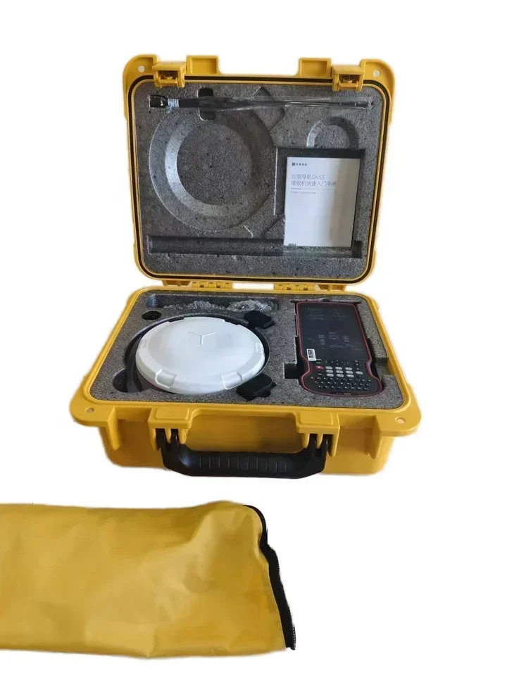
SINO T30 GNSS T300 RTK GPS System – High-Precision Measuring Instrument with 1590 Channels, Language Selectable, and Laser Measurement
Advanced GNSS RTK GPS system offering high precision with 1590 channels, language flexibility, and integrated laser measurement capabilities.
Short Description
The SINO T30 GNSS T300 RTK GPS System is a cutting-edge surveying tool designed to provide ultra-precise measurements for geospatial applications. With 1590 channels, language selection, and integrated laser measurement, this system ensures reliable and accurate results, making it ideal for large-scale land surveys, construction, and engineering projects.
Product Description
The SINO T30 GNSS T300 RTK GPS System offers top-tier performance with an impressive 1590 channels, ensuring comprehensive satellite coverage for accurate positioning. Its language-selectable feature makes it user-friendly for operators around the globe, and its integrated laser measurement function further enhances its versatility in the field. This system is perfect for surveying, mapping, geodesy, and construction applications that demand high precision.
Key Features
-
1590 Channels
Offers wide satellite coverage, ensuring precise positioning and reliable data collection in challenging environments. -
High Precision
Provides centimeter-level accuracy with RTK technology, ideal for professional surveying and mapping. -
Language Selectable
Multiple language options for easy operation and accessibility for users worldwide. -
Integrated Laser Measurement
Combines GNSS and laser measurement technologies for enhanced versatility in distance and position measurements. -
Durability and Reliability
Designed to withstand demanding field conditions, ensuring consistent performance and long-lasting operation.
Technical Specifications
-
GNSS System: GPS, GLONASS, Beidou, Galileo
-
RTK Accuracy: Centimeter-level precision
-
Channels: 1590 channels for broad satellite coverage
-
Laser Measurement: Integrated laser measurement for additional functionality in the field
-
Language Options: Multiple languages selectable for user convenience
-
Power Supply: Long-lasting rechargeable battery for extended field use
-
Operating Temperature: -20°C to 65°C
-
Waterproof and Dustproof: IP67 rating for protection against harsh environmental conditions
-
Dimensions: Compact and portable for ease of use and transportation
-
Weight: Lightweight for convenient field mobility
Applications / Usage
-
Land Surveying: Ideal for boundary surveys, topographic mapping, and large-scale land development projects.
-
Construction: Used in construction for precise positioning, site layout, and alignment tasks.
-
Geospatial Mapping: Perfect for detailed geospatial surveys, infrastructure mapping, and environmental studies.
-
Engineering: Essential for civil engineering projects, road construction, and urban planning.
-
Mining and Resource Management: Used for surveying in mining operations and natural resource management.
Summary
The SINO T30 GNSS T300 RTK GPS System is a high-performance, high-precision surveying instrument that integrates advanced GNSS technology with laser measurement functionality. With 1590 channels, multiple language options, and reliable performance in demanding conditions, it is an excellent choice for professionals in land surveying, construction, mapping, and engineering.


Related products


Factory Price Survey Instruments High Precision South NTS-362R10U/N6 ToTal Station NoN-prism For Land Surveying With English


32X DCJ-660 Laser Vertical Alignment Instrument Red Line Optical Surveying Electronic Vertical Instrument Laser Plummet


High Precision with IMU Function SMA26 Gnss Rtk Base And Rover Set For Land Surveying Instruments Gps Rtk receiver


