


High Precision CHCNAV GPS GNSS RTK Receiver I73 / X6 Land Surveying Measuring Instruments Gnss Rtk Base and Rover Gnss Rtk
- Pre-Order Available (Estimated ±15 Day Delivery)
- 7 day unit replacement guarantee(Video Unboxing Required)
- Including shipping costs, sent by Supplyinx.com
- Pick up at a supplyinx.com collection point is possible
- 24/7Customer service
Description
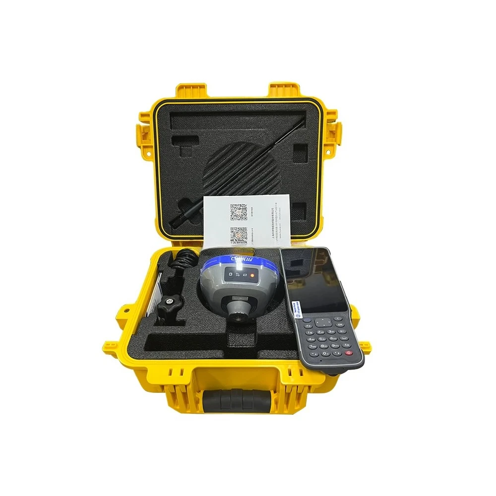
The CHCNAV I73 / X6 GNSS RTK Receiver is a high-precision surveying instrument designed to provide sub-centimeter accuracy for land surveying, topographic mapping, and geospatial applications. As a base and rover system, it offers real-time kinematic (RTK) capabilities, ensuring reliable positioning with high precision. With multi-constellation GNSS support (GPS, GLONASS, Galileo, BeiDou) and robust signal reception, the I73 / X6 is perfect for surveying professionals who require accurate and efficient data collection in various field conditions.
Product Description
The CHCNAV I73 / X6 GNSS RTK Receiver integrates advanced GNSS RTK technology for high-precision land surveying and geospatial mapping. The base and rover system enables real-time RTK corrections for precise positioning in both static and dynamic surveying environments. With support for GPS, GLONASS, Galileo, and BeiDou, the I73 / X6 ensures stable and reliable signal reception for accurate positioning in challenging environments. This receiver is designed for efficiency, portability, and ease of use, making it an ideal choice for surveying professionals in 2024.
Key Features
-
High-Precision RTK Technology: Provides real-time kinematic (RTK) corrections for sub-centimeter accuracy in positioning
-
Multi-Frequency GNSS Support: Supports GPS, GLONASS, Galileo, and BeiDou for reliable signal reception in challenging environments
-
Base and Rover System: Works as both a base station and rover, offering flexibility in surveying applications
-
Fast Signal Acquisition: Provides rapid data collection and positioning for increased efficiency in the field
-
Long Battery Life: Operates for 12-16 hours on a single charge, ideal for long surveying sessions
-
Rugged and Durable: IP67 waterproof and dustproof design ensures reliable operation in harsh outdoor environments
-
Compact and Portable: Lightweight and easy to carry, making it convenient for use in the field
-
Efficient Data Transfer: Bluetooth, Wi-Fi, and USB connectivity for fast data synchronization
-
User-Friendly Interface: Intuitive interface for easy operation and quick setup in the field
-
Cost-Effective Solution: Affordable price for a high-performance GNSS RTK surveying instrument
Technical Specifications (Example for CHCNAV I73 / X6 GNSS RTK Receiver)
| Specification | Details |
|---|---|
| Model | CHCNAV I73 / X6 GNSS RTK Receiver |
| Accuracy | Sub-centimeter (with RTK) |
| GNSS Channels | GPS, GLONASS, Galileo, BeiDou |
| Battery Life | 12-16 hours per charge |
| Connectivity | Bluetooth, Wi-Fi, USB |
| Protection | IP67 (waterproof and dustproof) |
| Display | LCD, user-friendly interface |
| Base and Rover Functionality | Yes |
| Dimensions | Compact and portable |
| Weight | 2-3 kg |
Applications
-
Land Surveying for topographic mapping, boundary surveys, and site development
-
Construction Surveying for site layout, building foundations, and infrastructure monitoring
-
Geodesy for high-precision mapping, coordinate system establishment, and geospatial data collection
-
Civil Engineering for road construction, bridge planning, and utility surveys
-
Mining and Agriculture for land management, crop monitoring, and resource management
-
Environmental Monitoring for land reclamation, ecosystem studies, and conservation projects
-
Urban Planning for city development, property surveying, and land use analysis
Summary
The CHCNAV I73 / X6 GNSS RTK Receiver is a high-precision GNSS RTK surveying instrument designed for sub-centimeter accuracy in land surveying and topographic mapping. With multi-frequency GNSS support, base and rover system, and long battery life, the I73 / X6 is perfect for surveying professionals working in challenging environments. Its compact design, user-friendly interface, and affordable pricing make it an excellent choice for surveying and geospatial applications in 2024. The durable design and efficiency make it suitable for long field sessions and demanding projects.


|
project
|
content
|
parameter
|
|
Receiver characteristics
|
satellite tracking
|
GPS+BDS+Glonass+Galileo+QZSS, supports the third generation of Beidou, supports five-star 16-band
|
|
|
number of channels
|
624 channels
|
|
|
operating system
|
LINUX system
|
|
|
Initialization time
|
<5s (typ.)
|
|
|
Initialization reliability
|
>99.99%
|
|
Receiver appearance
|
button
|
1 dynamic/static switch key, 1 power key
|
|
|
Indicator light
|
1 differential signal light, 1 satellite light, 1 static data acquisition light, 1 power light
|
|
Nominal accuracy
|
Static accuracy
|
Plane accuracy: ±(2.5+ 0.5×10⁻⁶×D) mm
|
|
|
|
Elevation accuracy: ±(5+0.5×10⁻⁶×D) mm
|
|
|
RTK accuracy
|
Plane accuracy: ±(8 + 1×10⁻⁶×D) mm
|
|
|
|
Elevation accuracy: ±(15+ 1×10⁻⁶×D) mm
|
|
|
Single machine accuracy
|
1.5m
|
|
|
Code difference accuracy
|
Plane accuracy: ±(0.25 + 1×10⁻⁶×D) m
|
|
|
|
Elevation accuracy: ±(0.5+ 1×10⁻⁶×D) m
|
|
Electrification parameters
|
Battery
|
Built-in 6800mAh lithium battery, supports 15 hours battery life of mobile station
|
|
|
External power supply
|
Support USB port external power supply
|
|
Physical properties
|
Size (L*W*H)
|
119mm*119mm*85mm
|
|
|
weight
|
0.73kg
|
|
|
Material
|
Magnesium alloy AZ91D body
|
|
|
Operating temperature
|
-45鈩儈+75鈩�
|
|
|
storage temperature
|
-55鈩儈+85鈩�
|
|
|
Waterproof and dustproof
|
IP68 level
|
|
|
Shock vibration
|
IK08 level
|
|
|
Anti-drop
|
Resistance to free fall of 2 meters
|
|
Data output
|
Output format
|
NMEA 0183, binary code
|
|
|
output method
|
BT/Wi-Fi/Radio
|
|
Static storage
|
storage format
|
Can directly record HCN, HRC, RINEX
|
|
|
storage
|
Standard 8GB built-in storage
|
|
|
Download method
|
Universal USB data download; HTTP download
|
|
Data communication
|
I/O interface
|
1 external UHF antenna interface
|
|
|
|
1 USB-TypeC interface, support charging, power supply, data download
|
|
|
Network module
|
Handbook supports 4G full Netcom
|
|
|
Radio station
|
Built-in high-frequency 450-470MHz single-receiving radio
|
|
|
Blue tooth
|
BT4.0, backward compatible with BT2.x, compatible with Windows, Android, IOS systems
|
|
|
data transmission
|
Wi-Fi data link
|
|
|
Wi-Fi
|
802.11 b/g/n
|
|
|
NFC
|
Support NFC flash connection
|
|
Receiver function
|
Super double collection
|
Support radio + network two-way data differential at the same time, provide comprehensive data services
|
|
|
One-click matching
|
Support handbook software to match base station data with one key
|
|
Handbook parameters
|
model
|
HCE600 Android Measuring Handbook
|
|
|
The internet
|
4G full Netcom, built-in eSIM free of three years of surveying and mapping traffic
|
|
|
operating system
|
Android 10
|
|
|
CPU
|
Eight-core 2.0Ghz processor
|
|
|
LCD screen
|
5.5” HD display
|
|
|
Battery
|
14 hours of battery life
|
|
|
Three defenses
|
IP68
|


Related products


NexStar 8SE Astronomical Telescope, Theodolite Bracket, Steel Tripod, Limit Gesture 14, 203/2000 Single Arm


Double Laser Electronic Theodolite High Precision Building Engineering Decoration Measuring Tools Precision Mapping Instrument


NT-023 Multi-functional Double Laser Red beam surveying instrument Electronic Theodolite


Foif RTS102R10 2″ Accuracy Total Station Measuring Surveying Instrument, 1000m Prism-free
Recently viewed items


