


Hi Target V90 plus Land Surveying Instrument GNSS RTK Base and Rover With Tilt survey and Electronic bubble
- Pre-Order Available (Estimated ±15 Day Delivery)
- 7 day unit replacement guarantee(Video Unboxing Required)
- Including shipping costs, sent by Supplyinx.com
- Pick up at a supplyinx.com collection point is possible
- 24/7Customer service
Description
Hi-Target V90 Plus Land Surveying Instrument GNSS RTK Base and Rover with Tilt Survey and Electronic Bubble
The Hi-Target V90 Plus is a high-performance GNSS RTK surveying instrument that includes both Base and Rover units, designed for land surveying and geospatial measurement tasks. This instrument is equipped with Tilt Survey and Electronic Bubble features, offering precise real-time data collection with increased productivity and efficiency. The V90 Plus is ideal for surveyors, construction professionals, and engineering teams who need reliable and accurate results in fieldwork. With advanced GNSS technology, it provides superior accuracy and versatility in a wide range of applications.
Key Features
-
High-Precision GNSS RTK Technology
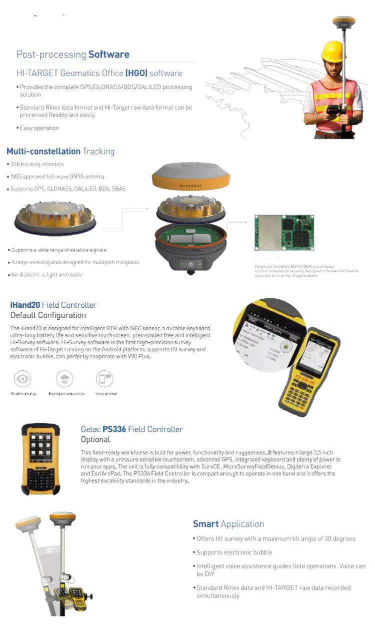
The Hi-Target V90 Plus incorporates dual-frequency GNSS and RTK (Real-Time Kinematic) technology, ensuring high-precision measurements in real-time. It can collect data quickly and accurately, providing sub-centimeter accuracy for both Base and Rover units in dynamic environments. -
Tilt Survey Technology
The Tilt Survey feature allows for accurate measurements without needing to hold the Rover pole perfectly vertical. This reduces the need for fine adjustments, speeding up the surveying process in challenging terrain and rough environments, allowing surveyors to gather data more efficiently and effectively. -
Electronic Bubble
The Electronic Bubble feature ensures that the surveying instrument is properly aligned, enhancing accuracy during setup and data collection. This ensures correct leveling of the Rover or Base station for precise positioning, especially when working in difficult-to-access areas or sloped terrains. -
Dual-Mode Base and Rover System
The V90 Plus supports both Base and Rover functionality, allowing for flexible surveying in different setups. The Base station collects data and sends corrections to the Rover, providing high-accuracy RTK solutions for field operations. -
Robust and Durable Design
Built to withstand the harshest conditions, the Hi-Target V90 Plus features a waterproof, dustproof, and shock-resistant design. It is IP67 rated, ensuring it remains operational in rain, mud, and extreme temperatures, making it perfect for fieldwork in rugged environments. -
Wireless Communication
The Hi-Target V90 Plus supports wireless communication between the Base and Rover units, allowing for seamless data transfer and improved efficiency during surveying tasks. This wireless functionality ensures that surveyors can work over long distances without the need for complicated cables or connections. -
Intuitive User Interface
The instrument features a user-friendly interface with a large display screen for easy operation and real-time data visualization. The software allows surveyors to set up surveys, view results, and adjust parameters with ease, streamlining the overall surveying process. -
Long Battery Life
The V90 Plus is equipped with long-lasting batteries, ensuring continuous operation throughout a full day of fieldwork without the need for frequent recharging. This enhances productivity, especially on long-duration surveying projects.
Technical Specifications
-
GNSS Technology: Dual-frequency GNSS with RTK (Real-Time Kinematic) for sub-centimeter accuracy
-
Frequency: L1, L2, L5 for high-precision positioning
-
Tilt Survey Technology: Allows measurements with up to a 30° tilt without loss of accuracy
-
Electronic Bubble: Ensures correct leveling for accurate data collection
-
IP Rating: IP67 (dustproof, waterproof, and resistant to harsh environments)
-
Data Communication: Wireless communication for Base and Rover units
-
Battery Life: Up to 12 hours of continuous operation on a full charge
-
Display: Large color screen for real-time data monitoring and system settings
-
Accuracy:
-
Horizontal: ±8mm + 1ppm
-
Vertical: ±15mm + 1ppm
-
-
Compatibility: Works with Hi-Target field software for easy integration with surveying workflows
Applications
-
Land Surveying:
The Hi-Target V90 Plus is ideal for land surveying applications, including topographic surveys, boundary marking, and land subdivision. Its high-accuracy RTK technology ensures precise results for geospatial mapping and site planning. -
Construction:
In construction projects, the V90 Plus provides precise measurements for building foundations, road layout, site leveling, and alignment. Its Tilt Survey and electronic bubble features are perfect for working in uneven terrains and rough environments. -
Mining and Geospatial Projects:
The instrument is useful for mining surveys and geospatial data collection, providing precise measurements in areas where traditional methods are challenging or time-consuming. The wireless communication between Base and Rover units allows for efficient large-area mapping. -
Agricultural Surveying:
The V90 Plus can also be applied in agriculture, helping professionals with precision farming, land leveling, and irrigation mapping. The ability to measure slopes and terrain accurately makes it ideal for field management. -
Environmental Studies:
The instrument is perfect for environmental surveys, including water flow monitoring, topographic mapping, and land reclamation. Its Tilt Survey technology ensures that measurements can be taken in challenging field conditions without sacrificing accuracy.
Summary
The Hi-Target V90 Plus GNSS RTK Land Surveying Instrument is a cutting-edge solution for surveying professionals seeking precision, efficiency, and reliability in the field. With its dual-frequency GNSS RTK technology, Tilt Survey feature, electronic bubble, and wireless communication, the V90 Plus ensures accurate data collection for a wide range of surveying and geospatial applications. Its rugged design, long battery life, and user-friendly interface make it the perfect tool for professionals working in construction, land surveying, mining, and environmental studies. Whether you are measuring elevations, distances, or coordinates, the Hi-Target V90 Plus guarantees high-precision results in any environment.
|
Model |
V90 plus |
||
|
System Configuration |
Data storage |
8GB Internal storage (Support up to 32GB external SD card) |
|
|
Record GNS and RINEX fo rmat simultaneously |
|||
|
Data Formats |
1Hz positioning output, up to 50Hz |
||
|
CMR: CMR, CMR+, sCMRx input and output |
|||
|
RTCM: RTCM 2.1, 2.2,2.3, 3.0, 3.1, 3.2 input and output |
|||
|
Navigation outputs ASCII: NMEA-0183 GSV, AVR, RMC, HDT, VGK, VHD, ROT, GGK, GGA, GSA, ZDA, VTG, GST, PJT, PJK, BPQ, GLL, GRS, GBS |
|||
|
Navigation outputs binary: GSOF |
|||
|
Satellite Signals Tracked Simultaneously |
Channels |
220 |
|
|
BDS |
B1,B2 |
||
|
GPS |
Simultaneous L1C/A, L2C, L2E, L5 |
||
|
GLONASS |
Simultaneous L1C/A, L1P, L2C/A (GLONASS M only), L2P |
||
|
SBAS |
Simultaneous L1 C/A, L5 |
||
|
GALILEO |
Simultaneous L1 BOC, E5A, E5B, E5AltBOC |
||
|
Static and Fast Static GNSS Surveying |
Horizontal |
2.5mm+0.5ppm RMS |
|
|
Vertical |
5mm+0.5ppm RMS |
||
|
Post Processing Kinematic (PPK / Stop & Go) GNSS Surveying |
Horizontal |
1cm+1ppm RMS |
|
|
Vertical |
2.5cm+1ppm RMS |
||
|
Initialization time |
Typically 10 minutes for base while 5minutes for rover |
||
|
Initialization reliability |
Typically > 99.9% |
||
|
Network RTK |
Horizontal |
8mm+1ppm RMS |
|
|
Vertical |
15mm+0.5ppm RMS |
||
|
Initialization time |
Typically < 8seconds |
||
|
Initialization reliability |
Typically > 99.9% |
||
|
Code Differential GNSS Positioning |
Horizontal |
25cm+1ppm RMS |
|
|
Vertical |
50cm+1ppm RMS |
||
|
SBAS |
0.50m Horizontal, 0.85m Vertical |
||
|
Power and Battery |
Power |
6V to 28V DC external power input, Power consumption ≤3.5W |
|
|
Internal battery |
Rechargeable, removable 7.4V, 5000mAh Lithium-ion battery |
||
|
Internal battery life |
Static 12hours |
||
|
RTK rover (UHF/GPRS/3G) 10 hours |
|||
|
RTK base more than 8 hours |
|||
|
I/O Interface |
1 xBluetooth, NFC ,1 x standard USB2.0 port , 1 x TNC antenna connector, 1 x RS232 serial port ,1 x DC power input (5-pin) , 1 x MicroSD card port |
||
|
Physical |
Dimensions (W x H) |
153mm x 83mm (6.02inch x 3.27inch) |
|
|
Weight(without internal battery) |
950g (2.09lb) |
||
|
Operating temperature |
-40ºC to +65ºC (-40ºF to +149ºF) |
||
|
Storage temperature |
-55ºC to +85ºC (-67ºF to +185ºF) |
||
|
Humidity |
100%, considering |
||
|
Water/dustproof |
IP67 dustproof, protected from temporary immersion to depth of 1m (3.28ft). |
||
|
Shock and vibration |
Designed to survive a 3m(9.84ft) natural fall onto concrete. |
||


Related products


20PCS Laser Distance Meter Rangefinder Range Finder Build Measure Device Test Tool 40M/131ft/1575in


JUWEI17-100 Wide dovetail groove astronomical telescopes harmonic equatorial instrument compatible with theodolites


High Precision with IMU Function SMA26 Gnss Rtk Base And Rover Set For Land Surveying Instruments Gps Rtk receiver


Double Laser Electronic Theodolite High Precision Building Engineering Decoration Measuring Tools Precision Mapping Instrument
Recently viewed items


Digital Coffee TDS Refractometer Accurate Pocket Coffee Concentration Tester

0-22%(0.15%)Digital Coffee TDS Refractometer Pocket Tester Concentration Densitometer Measuring Tool Alcohol Meter


High Precision Geographic Theodolite Surveying Measuring Optical Mechanic Theodolite

