


Harbin Geologic Compass DQL-2A Aluminum alloy theodolite Professional Surveying
- Pre-Order Available (Estimated ±15 Day Delivery)
- 7 day unit replacement guarantee(Video Unboxing Required)
- Including shipping costs, sent by Supplyinx.com
- Pick up at a supplyinx.com collection point is possible
- 24/7Customer service
Description
Harbin Geologic Compass DQL-2A Aluminum Alloy Theodolite Professional Surveying
The Harbin Geologic Compass DQL-2A is a precision instrument designed for geological surveys and professional surveying applications. Made from aluminum alloy, this theodolite compass combines the functionalities of a geological compass with a high-accuracy theodolite, making it an ideal tool for measuring angles and orientation of geological structures such as fault lines, rock layers, and strata. It is engineered for use in fieldwork, providing reliable, accurate measurements for a range of geospatial tasks, including land surveying, mining exploration, and construction layout.
Key Features
-
Aluminum Alloy Construction
The DQL-2A features aluminum alloy in its construction, ensuring a lightweight and durable design. This material provides the instrument with both strength and portability, making it easy to transport during field surveys while maintaining robust performance. -
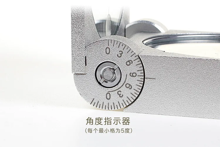
High-Precision Angular Measurement
The compass offers accurate angular measurements in both horizontal and vertical planes, which is crucial for determining azimuths, strike angles, and dip angles in geological surveys. This makes it suitable for mapping geological formations, fault studies, and terrain analysis. -
Geological Compass and Theodolite Hybrid
Combining geological compass and theodolite functionalities, the DQL-2A allows users to measure geological strike and dip angles with high precision. This hybrid feature makes it especially useful in geological mapping and surveying, where both compass and angular measurements are required for accurate fieldwork. -
Adjustable Sighting Mechanism
The compass is equipped with a precise sighting mechanism, allowing for accurate alignment with distant objects or geological features. This ensures that you can measure angles over long distances without errors in alignment. -
Wide Application Range
The Harbin Geologic Compass DQL-2A is designed for professional surveying, geological field studies, and mining exploration. Its accuracy and rugged design make it ideal for surveying complex geological structures, topographic mapping, and environmental surveys. -
Weather-Resistant Design
Built for field use, the compass is weather-resistant, providing durability in harsh outdoor environments. Whether working in rain, snow, or extreme temperatures, the DQL-2A ensures consistent performance in all conditions.
Technical Specifications
-
Material:
-
Aluminum alloy construction for lightweight and durable design
-
-
Angular Measurement:
-
Precision: ±0.5° for horizontal and vertical angles
-
Range: Measures horizontal azimuths, dip angles, and strike angles
-
-
Sighting Mechanism:
-
Adjustable sighting system for accurate alignment with objects or geological features
-
-
Application:
-
Geological compass for fieldwork and topographic studies
-
Theodolite function for angular measurements in land surveying
-
-
Weather Resistance:
-
Weather-resistant design suitable for outdoor field use in tough conditions
-
-
Size and Weight:
-
Compact and portable, designed for easy transport in the field
-
-
Power:
-
No external power source required, manual operation
-
Applications
-
Geological Field Surveys:
The DQL-2A is ideal for geologists and surveyors working in field environments, providing accurate measurements of geological strata, fault lines, and land formations. It’s an essential tool for studying rock formations, terrain analysis, and mapping geological structures. -
Mining Exploration:
The compass is used for mining and mineral exploration, helping professionals map out mineral deposits, study rock orientations, and evaluate mining sites. Its precision is crucial for identifying geological formations that may contain valuable resources. -
Construction and Infrastructure:
The Harbin Geologic Compass is also used in construction projects to measure slope and alignment for roads, bridges, and other infrastructure developments. Accurate surveying ensures proper site preparation and foundation alignment. -
Environmental Studies:
For environmental studies, the DQL-2A helps assess soil composition, topography, and land stability, allowing researchers to understand the impacts of natural processes or human activities on the land. -
Surveying:
This instrument is widely used in land surveying for boundary mapping, site surveys, and topographical mapping, offering accurate angle measurements essential for construction, land division, and property development.
Summary
The Harbin Geologic Compass DQL-2A is a precision surveying instrument combining geological compass and theodolite functionality, making it ideal for geological surveys, mining exploration, and professional surveying. Constructed from aluminum alloy, this lightweight yet durable compass offers high-precision angular measurements for geological mapping, fault analysis, and terrain studies. Its weather-resistant design ensures that it can withstand harsh field conditions, while its adjustable sighting mechanism allows for precise alignment. Whether you’re working on geological studies, mining exploration, or land surveying, the DQL-2A is an essential tool for ensuring reliable, accurate data in the field.


‘
Related products


NT-023 Multi-functional Double Laser Red beam surveying instrument Electronic Theodolite


High Precision with IMU Function SMA26 Gnss Rtk Base And Rover Set For Land Surveying Instruments Gps Rtk receiver


JUWEI17-100 Wide dovetail groove astronomical telescopes harmonic equatorial instrument compatible with theodolites


Recently viewed items


