
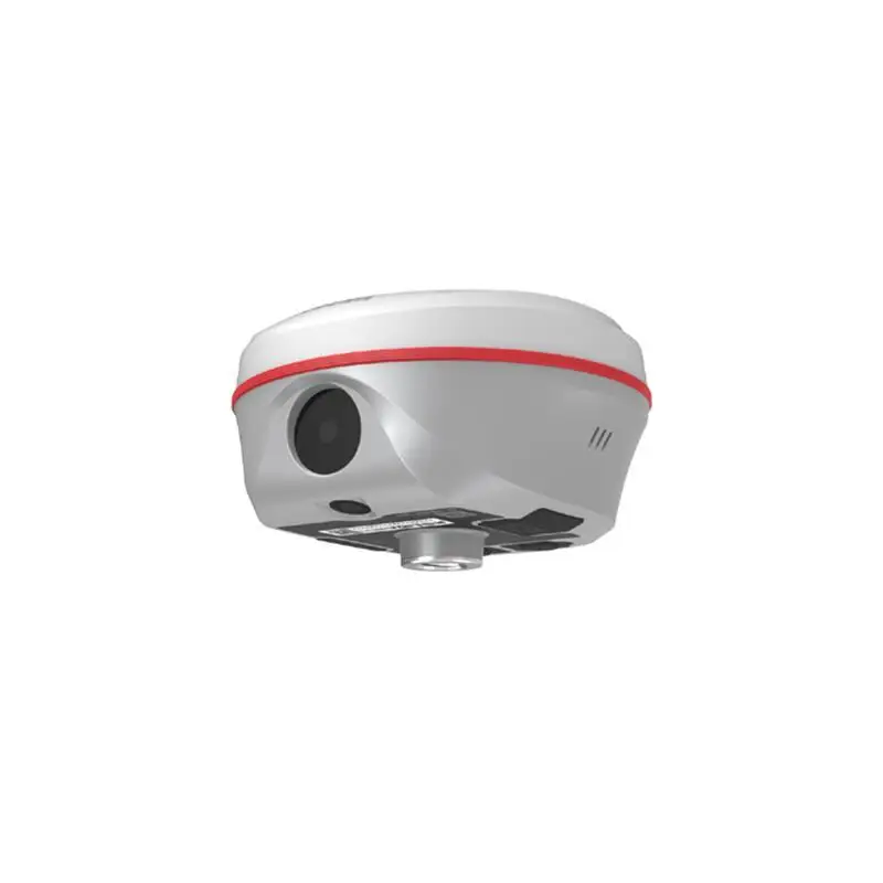


Compact Design Visual Positioning Stakeout 3D Modeg 1598 Channels Imu Gps Receiver Surveying Equipment K50 Gnss
- Pre-Order Available (Estimated ±15 Day Delivery)
- 7 day unit replacement guarantee(Video Unboxing Required)
- Including shipping costs, sent by Supplyinx.com
- Pick up at a supplyinx.com collection point is possible
- 24/7Customer service
Description
Compact Design Visual Positioning Stakeout 3D Mode 1598 Channels IMU GPS Receiver Surveying Equipment K50 GNSS
The K50 GNSS Receiver is a high-precision and compact surveying equipment that integrates IMU (Inertial Measurement Unit) technology with GNSS for reliable visual positioning, stakeout tasks, and 3D modeling. It features 1598 channels for multiple satellite system support, enabling users to perform accurate surveying and mapping tasks in dynamic environments. The K50 GNSS is designed for professionals in geospatial industries, offering real-time positioning and stakeout solutions for land surveying, construction, and engineering projects.
Key Features
-
1598 Channels for Multi-System Support
The K50 GNSS Receiver is equipped with 1598 channels that allow for dual-frequency support from multiple satellite systems, such as GPS, GLONASS, Beidou, Galileo, and QZSS. This extensive channel support ensures high accuracy and reliable positioning even in challenging environments. -
IMU Technology for Dynamic Positioning
With integrated IMU technology, the K50 GNSS delivers enhanced visual positioning and stakeout capabilities in dynamic environments, including when moving or during complex field measurements. The IMU function compensates for temporary signal loss and provides continuous real-time data to help you achieve consistent accuracy. -
3D Mode for Advanced Surveying
The K50 GNSS supports 3D Mode for advanced positioning and surveying tasks. This allows you to collect precise spatial data for landscaping, topographic surveys, construction layout, and civil engineering projects, ensuring accurate height, depth, and position information for all types of three-dimensional surveying. -
Compact and Rugged Design
Designed with portability and field durability in mind, the K50 GNSS features a compact design that is both lightweight and rugged, making it easy to carry and set up. It is perfect for professionals who need a reliable GPS receiver that can withstand harsh conditions and challenging terrain. -
High Precision and Real-Time Data
The K50 GNSS Receiver offers high precision positioning with real-time data output. Whether you’re working on a land surveying project, building construction, or geospatial mapping, the receiver provides accurate and reliable data to improve the quality and efficiency of your work. -
Visual Positioning Stakeout
The visual positioning stakeout feature provides an easy-to-use interface for site layout and staking out. The receiver helps ensure that your project is aligned correctly with design specifications, making it essential for construction projects that require precise stakeout positions. -
Flexible and Multi-Function Interface
The K50 GNSS is designed for integration with various surveying software and mapping applications, making it a versatile tool in any surveying professional’s arsenal. The equipment can be used in conjunction with RTK systems, UAVs, and GIS tools, enhancing its flexibility for all types of geospatial work.
Technical Specifications
-
Number of Channels: 1598 channels
-
Satellite Systems Supported: GPS, GLONASS, Beidou, Galileo, QZSS
-
Accuracy: High-precision GNSS receiver providing sub-centimeter accuracy
-
IMU Integration: For enhanced dynamic positioning and real-time compensation during signal loss
-
3D Mode: For three-dimensional surveying and advanced spatial data collection
-
Interface: Compatible with surveying software and RTK systems
-
Portability: Compact design for easy transport and setup
-
Durability: Weatherproof, shock-resistant, and field-ready for harsh environments
-
Battery Life: Long-lasting battery for extended field use
-
Display: High-resolution display for real-time data monitoring
-
Data Transfer: Wireless connectivity for seamless data transfer to field computers or tablets
Applications
-
Land Surveying:
The K50 GNSS is perfect for land surveying tasks such as boundary marking, topographic surveys, and land subdivision. Its high accuracy and IMU technology make it ideal for mapping large areas with reliable positioning data. -
Construction and Site Layout:
For construction professionals, the K50 GNSS ensures accurate site layout, foundation marking, and alignment of structures. The visual positioning stakeout feature helps you mark positions and verify design specifications with ease. -
Geospatial Mapping:
The K50 GNSS is used in geospatial mapping applications that require precise positioning for tasks such as urban planning, infrastructure mapping, and land-use surveys. Its 3D mode allows for advanced spatial data collection and terrain analysis. -
Agricultural Surveying:
The K50 GNSS is also ideal for precision agriculture, where it is used to create accurate maps for irrigation, crop management, and land leveling. The real-time data output and dynamic positioning capabilities help improve agricultural productivity. -
Mining and Environmental Monitoring:
In mining and environmental surveys, the K50 GNSS helps professionals conduct site surveys, monitor land reclamation, and track natural resource management. Its robust design ensures it performs well in challenging terrains.
Summary
The K50 GNSS Receiver is a compact, high-precision surveying tool that integrates IMU technology for enhanced real-time positioning and 3D surveying capabilities. With 1598 channels supporting multiple satellite systems, high accuracy, and a weather-resistant design, the K50 GNSS is the perfect solution for land surveying, construction layout, geospatial mapping, and other geospatial data collection tasks. Its portable and rugged design ensures that it can withstand harsh field conditions, making it an essential tool for professionals who require precise, real-time location data.


Data Collection,By Shooting Video or Photo

Stakeout, with Dual-Camera


|
|
product name
|
kolida k50
|
|
Measurement Performance
|
Signal tracking
|
BDS-2:B1I, B2I, B3I; BDS-3:B1I, B3I, B1C, B2a, B2b
|
|
GPS:L1C/A,L2P,L2C,L5,L1C*
|
||
|
GLONASS: G1, G2, G3*
|
||
|
Galileo: E1,E5b,E5a,E5 AltBoc*,E6c*
|
||
|
SBAS: L1C/A,L5*
|
||
|
QZSS: L1, L2C, L5;
|
||
|
IRNSS: L5*
|
||
|
1598 channels
|
||
|
GNSS features
|
Positioning output frequency 1Hz to 20Hz; initialisation time less than 10 seconds
|
|
|
Initialisation reliability >99.99%
|
||
|
|
||
|
Highly reliable carrier tracking technology, which greatly improves carrier accuracy and provides users with high quality raw
observation data |
||
|
distant positioning environments
|
||
|
Highly accurate positioning processing engine
|
||
|
Positioning Accuracy
|
Static CNSS measurements
|
Horizontal: ±2.5mm +0.5 ppm
Vertical: ±5mm +0.5 ppm |
|
Real-time dynamic measurement
|
Horizontal: ±8mm +0.5 ppm
Vertical : ±15mm +0.5 ppm |
|
|
Operating Systems/User Interaction
|
Operating system: Linux
|
|
|
Keypad: single button
|
||
|
|
||
|
Web interaction: support WI-FI and USB mode to access the receiver built-in Web management page, monitor the host status, free
configuration of the host, etc. |
||
|
Chinese,English, Korean, Russian, Portuguese, Spanish, Turkish
|
||
|
Secondary development: provide secondary development package, open OpenSIC observation data format and interaction interface
definition for secondary development |
||
|
Data cloud service: powerful cloud service management platform, allowing remote management and configuration of equipment, viewing
progress, managing jobs, etc. Can use Qualitec servers or build your own servers |
||
|
Hardware
|
Size: 134mm*79.1mm (diameter, height)
|
|
|
Weight: 880g (with battery)
|
||
|
Material: magnesium alloy
|
||
|
Operating temperature: -45 ℃~+75°℃; storage temperature: -55°C~+85 ℃℃
|
||
|
Humidity resistant to 100% condensation
|
||
|
|
||
|
Resistant to a 2 m drop with a pole
|
||
|
Electrical
|
Battery:7.4V, 6800mAh unremovable battery
|
|
|
Battery Life: 10-15 hours
|
||
|
Communication
|
I/O ports
|
antenna interface
|
|
Radio modems
|
|
|
|
4G all-access
|
network antenna
|
|
|
|
||
|
Bluetooth
|
BT4.2(BR/EDR+BLE)
|
|
|
NFC wireless communication
|
NFC wireless communication technology, Bluetooth automatic pairing can be achieved by touching the handbook and the main unit
(requires handbook also equipped with NFC wireless communication module) |
|
|
eSIM (optional)
|
operation of the host computer, supporting external card solutions
|
|
|
WIFI
|
Standard
|
802.11b/g/n standard
Supports 2.4g/5g WiFi |
|
WIFI Hotspot
|
functions
|
|
|
|
||
|
WIFI data chain
|
Receiver can be connected to WIFI for differential data broadcast or reception via WIFI
|
|
|
Data Storage/Transfer
|
Data storage
|
16G internal solid state memory
|
|
Auto-cycle storage (automatically delete the earliest data when there is not enough storage space)
|
||
|
|
||
|
Data transfer
|
Plug-and-play USB data transfer method
|
|
|
Supports USB, FTP download, HTTP data transfer
|
||
|
Data format
|
Static data formats: Southern STH, Rinex 2.01 and Rinex 3.02 and many more
|
|
|
Differential data formats: RTCM3.0, RTCM3.2
|
||
|
GPS output data formats: NMEA 0183, PJK planar coordinates, binary codes
|
||
|
|
||
|
Sensors
|
Inertial tilt measurement
|
Built-in IMU inertial measurement sensor, supports inertial tilt measurement function, automatically corrects coordinates
according to the tilt direction and angle of the centering rod |
|
Tilt angle: 0°~60°; IMU update rate: 200HZ
|
||
|
Tilt compensation accuracy
|
1.8 m pole; RMS: 8 mm + 0.7 mm/°tilt
|
|
|
Temperature sensors
|
and adjustment of the host temperature
|
|
|
AR Stakeout
|
pixel
|
8 million
|
|
|
Accuracy
|
Typical homework scenario, measurement distance 2-15m,RMS accuracy: 4cm
|
Related products


KP-128 Marine GPS Satellite Navigator Satellite Locator Theodolite High Sensitivity Accuracy marine GPS Boat Parts


20PCS Laser Distance Meter Rangefinder Range Finder Build Measure Device Test Tool 40M/131ft/1575in


Recently viewed items


