


Cheapest Gnss Receiver 1590 Channels K803 Board Network RTK NTRIP CORS Gps Rtk Sino A10 Surveying Instrument
- Pre-Order Available (Estimated ±15 Day Delivery)
- 7 day unit replacement guarantee(Video Unboxing Required)
- Including shipping costs, sent by Supplyinx.com
- Pick up at a supplyinx.com collection point is possible
- 24/7Customer service
Description
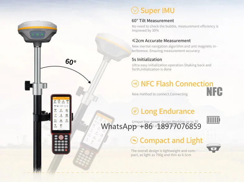
Sino A10 adalah GNSS RTK Receiver ekonomis dengan 1590 channel berbasis papan K803, mendukung seluruh konstelasi satelit utama. Alat ini dilengkapi fitur Network RTK, NTRIP, dan kompatibilitas CORS, sehingga mampu memberikan akurasi tinggi dengan biaya terjangkau. Desainnya ringkas, ringan, serta mudah digunakan, menjadikannya pilihan ideal untuk survei lahan, konstruksi, dan pemetaan infrastruktur dengan harga paling murah (cheapest GNSS receiver) di kelasnya.
Spesifikasi Utama
-
Channels: 1590, mendukung GPS, GLONASS, BeiDou, Galileo, QZSS, SBAS
-
Board: K803 high-performance GNSS board
-
Akurasi RTK: H: ±8 mm + 1 ppm, V: ±15 mm + 1 ppm
-
Fitur:
-
Network RTK, NTRIP Client/Server
-
Kompatibel CORS untuk koreksi real-time
-
IMU tilt compensation (hingga ±60°)
-
E-Bubble, auto-initialization
-
-
Komunikasi: 4G LTE, Wi-Fi, Bluetooth, UHF radio internal
-
Daya: Baterai Li-ion, durasi kerja ±10–12 jam
-
Ketahanan: IP67 tahan air & debu, tahan jatuh ±2 m
-
Desain: Kompak, lightweight, easy to carry
Pengaplikasian
-
Survei geodesi & topografi
-
Pemetaan lahan & batas properti
-
Setting-out proyek sipil & infrastruktur
-
Monitoring & pemetaan berbasis CORS/RTK Network


|
GNSS Performance |
Channels
|
1598
|
|
|
GPS
|
L1C/A,L2P,L1C,L2C,L5
|
|
|
GLONASS
|
G1C,G1P,G2C,G2P,G3
|
|
|
Galileo
|
E1,E5b,E5a,E5AltBoc,E6c
|
|
|
BDS-2
|
B1, B2, B3
|
|
|
BDS-3
|
B1C,B2a,B2b,B2b-ppp
|
|
|
SBAS
|
L1C/A,L5C
|
|
|
QZSS
|
L1C/A,L2C,L5,L1C,L1s,L5s,L6
|
|
|
IRNSS
|
L5
|
|
GNSS Accuracies
|
Static and Fast Static
|
Horizontal: 2.5 mm + 0.5 ppm
Vertical: 5 mm + 0.5 ppm |
|
|
Long Observations Static
|
Horizontal: 3 mm + 0.1 ppm
Vertical: 3.5 mm + 0.4 ppm |
|
|
Real Time Kinematic
|
Horizontal: 8mm+1ppm
Vertical: 15 mm + 1 ppm |
|
|
DGPS
|
<0.4 m RMS
|
|
|
SBAS
|
1 m 3D RMS
|
|
|
Standalone
|
1.5 m 3D RMS
|
|
|
PPP
|
Horizontal锛�10cm 锛沄ertical锛�20cm
|
|
Hardware
|
Size
|
肖130*65.5mm
|
|
|
Weight
|
790g
|
|
|
Environment
|
Operating:-30鈩�—+65鈩�
Storage: -40鈩�—+85鈩� |
|
|
Humidity
|
100% condensation
|
|
|
Ingress protection
|
IP67
|
|
|
Shock
|
Survive a 2-meter pole drop
|
|
|
Tilt sensor
|
Calibration-free IMU integrated for tilt survey up to 60°tilt with 2.5 cm accuracy
|
|
Communication |
Serial port
|
supports serial communication
|
|
|
USB
|
TYPE-C interface
|
|
|
Data protocols
|
LTE-FDD, LTE-TDD, DC-HSDPA HSPA+銆丠SDPA銆丠SUPA銆乄CDMA銆� TD-SCDMA銆丆DMA銆丒DGE銆丟PRS
|
|
|
Antenna
|
Three in one antenna
|
|
|
Data formats |
NMEA-0183锛� GPGGA銆丟PGSV銆丟PGSA銆丟PRMC銆� GPVTG銆丟PZDA Sinan binary format: cnb (sinognss custom) RTCM2.x锛� RTCM1B銆丷TCM3B銆丷TCM9B銆�
RTCM1819B銆丷TCM59B RTCM3.0锛� 1004銆�1005銆�1006銆�1007銆�1008銆�1011銆� 1104銆�1033
RTCM3.2锛� MSM4銆丮SM5
|
|
|
WIFI
|
802.11b/g/n
|
|
Electrical |
Power consumption
|
1.4W
|
|
|
Battery Capacity
|
≤30h
|
|
|
Input voltage:
|
6-28 VDC
|
|
|
Shell material
|
magnesium aluminum alloy shell
|
Related products


QD-02L High Quality Theodolite Surveying Instrument Digital Laser Optical Theodolite for Surveying and Mapping Instruments


DEKO 4D 16 Lines Self-Leveling Laser Level 360 Horizontal and Vertical Cross Line Green Laser Beam with Tripod Power Tools


KP-128 Marine GPS Satellite Navigator Satellite Locator Theodolite High Sensitivity Accuracy marine GPS Boat Parts


Rangefinder 1500 Meters Binoculars 10×42 Waterproof Adult Birdwatching Binoculars


Recently viewed items


