


CHC X15/I89 Price Surveying Instrument Gps Rtk With Perment Code Land Survey Equipment Gnss Rtk
- Pre-Order Available (Estimated ±15 Day Delivery)
- 7 day unit replacement guarantee(Video Unboxing Required)
- Including shipping costs, sent by Supplyinx.com
- Pick up at a supplyinx.com collection point is possible
- 24/7Customer service
Description
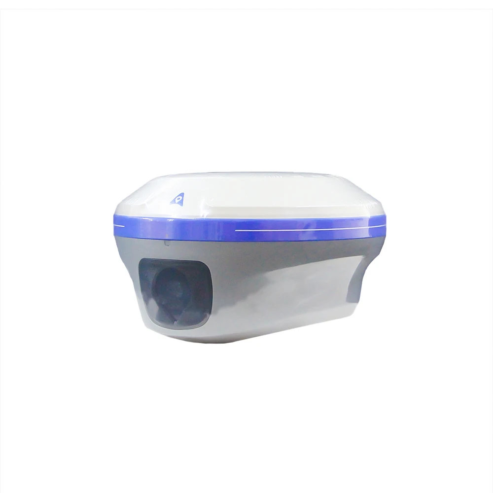
The CHC X15/I89 GPS RTK Surveying Instrument is a high-precision GNSS RTK receiver designed for land surveying, geodesy, and topographic mapping. Equipped with permanent code technology, this instrument provides sub-centimeter accuracy in real-time positioning. With advanced RTK (Real-Time Kinematic) capabilities and multi-constellation GNSS support (GPS, GLONASS, Galileo, BeiDou), the CHC X15/I89 is designed to deliver reliable and accurate measurements for surveying projects in various field conditions. Its affordable price and robust design make it an excellent choice for professionals who require high-quality performance without exceeding budget constraints.
Product Description
The CHC X15/I89 GPS RTK Surveying Instrument provides precise, real-time positioning through RTK technology, offering sub-centimeter accuracy for land surveying and mapping tasks. The permanent code ensures reliable signal processing even in challenging environments, enabling real-time corrections and accurate data collection. The X15/I89 is compatible with multi-frequence GNSS signals from GPS, GLONASS, Galileo, and BeiDou, making it capable of providing high-quality positioning and measurements in difficult field conditions. Whether for boundary surveys, site development, or topographic surveys, this device offers the accuracy, efficiency, and reliability needed in the modern surveying industry.
Key Features
-
Permanent Code Technology: Provides consistent and reliable data processing for high-accuracy positioning with RTK corrections
-
Multi-Frequency GNSS: Supports GPS, GLONASS, Galileo, and BeiDou, ensuring global satellite coverage and better signal reception
-
Sub-centimeter Accuracy: Achieve high-precision measurements in real-time, ideal for land surveying, topographic mapping, and construction projects
-
Real-Time Kinematic (RTK): Provides instant corrections for sub-centimeter precision in positioning and coordinate measurement
-
Multi-Channel Reception: Enhanced signal reception from multiple constellations for improved reliability and accuracy
-
Long Battery Life: Operates up to 12-16 hours on a single charge, making it suitable for extended fieldwork
-
Robust Design: IP67 rating for dustproof and waterproof operation, making it suitable for use in harsh environments
-
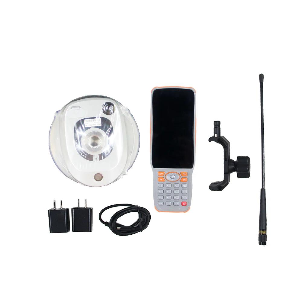
Easy Data Transfer: Equipped with Bluetooth, Wi-Fi, and USB for fast and efficient data transfer to other devices
-
Affordable Price: Offers high-quality performance at a competitive price, making it a cost-effective solution for surveying professionals
Technical Specifications (Example for CHC X15/I89 GPS RTK Surveying Instrument)
| Specification | Details |
|---|---|
| Model | CHC X15/I89 GPS RTK Surveying Instrument |
| Permanent Code | Yes |
| GNSS Channels | Multi-frequence (GPS, GLONASS, Galileo, BeiDou) |
| Accuracy | Sub-centimeter (RTK) |
| Battery Life | 12-16 hours per charge |
| Display | LCD large screen, user-friendly interface |
| Konektivitas | Bluetooth, Wi-Fi, USB |
| Protection | IP67 (dustproof and waterproof) |
| Weight | 2-3 kg |
| Dimensions | Compact and portable |
Applications
-
Land surveying for topographic mapping, boundary surveys, and site planning
-
Construction surveying for site layout, building foundations, and monitoring
-
Geodesy for high-precision mapping and coordinate system establishment
-
Civil Engineering for road construction, bridge planning, and infrastructure development
-
Mining and agriculture for land management, crop monitoring, and resource management
-
Urban Planning for city development, utilities management, and site surveys
-
Environmental Monitoring for land reclamation, ecosystem studies, and conservation projects
Summary
The CHC X15/I89 GPS RTK Surveying Instrument with Permanent Code offers sub-centimeter accuracy for real-time positioning. With multi-frequency GNSS support, RTK technology, and permanent code, this instrument ensures precise, reliable measurements for land surveying, topographic mapping, and construction projects. Long battery life, user-friendly operation, and affordable pricing make it an excellent choice for surveying professionals in 2024, offering exceptional performance with cost-effective solutions


| TECHNICAL PARAMETER | ||
| project | content | index |
| Satellite tracking | Satellite system | GPS+BDS+Glonass+Galileo+QZSS |
| Support Beidou three generations, support Five star 21 frequency point | ||
| Satellite tracking | BDS: B1I,B2I,B3I,B1C,B2a,B2b* | |
| GPS: L1C/A,L1C,L2C,L2P,L5 | ||
| GLONASS: G1,G2,G3 | ||
| Galileo: E1,E5a,E5b,E6* | ||
| QZSS: L1C/A,L1C,L2C,L5 | ||
| IRNSS: L5* | ||
| SBAS: L1C/A* | ||
| Channel | 1408 | |
| Initialization reliability | 99.99% | |
| No network continued test | support | |
| Signal acquisition sensitivity | Typical value -162 dbm, the ability to capture weak signals is stronger | |
| Accuracy | Static accuracy | Planar accuracy:±(2.5mm + 0.5×10⁻⁶×D)mm |
| Elevation accuracy:±(5mm + 0.5×10⁻⁶×D)mm | ||
| RTK accuracy | Planar accuracy:±( 8mm + 1×10⁻⁶×D)mm | |
| Elevation accuracy:±(15mm + 1×10⁻⁶×D)mm | ||
| Tilt compensation accuracy | 8mm + 0.3mm /° tilt (accuracy <2.5cm within 30°) | |
| Video measurement accuracy | Typical 2~4cm, measuring distance 2~ 15m | |
| GNSS+ Inertial navigation | IMU update rate | 200Hz |
| Tilt Angle | 0-60° | |
| Insensitive super inertial navigation | No initialization is required, the INS will not exit after initialization | |
| User interaction | Pilot lamp | 1 satellite light +1 differential data light +1 static indicator light +1 power light |
| key | Static switch button + Power/Confirm button | |
| web page | Support PC/ mobile web page | |
| camera | Characteristic function | Video measurement, efficiency increase by 60%* |
| 3D modeling, double the efficiency of internal and external work * | ||
| AR real navigation, put a point not lost | ||
| Visual lofting, one stick in place | ||
| pixel | 2MP&5MP | |
| Frame rate | 25Hz | |
| Field of view (H, V) | 75°,75° | |
| illuminance | Starlight camera, OmniPixel 3-GS technology | |
| Full color picture at 0.01lux | ||
| Physical characteristics | dimension | Φ133.5mm*80mm |
| weight | 725g (battery included) | |
| material | Magnesium alloy | |
| Operating temperature | -45鈩儈+75鈩� | |
| Storage temperature | -55鈩儈+85鈩� | |
| Waterproof and dustproof | IP68 (30 minutes underwater 1 meter immersion) | |
| anticollision | IK08 (subjected to the same mechanical impact as the 2.5kg steel ram without damage, resistance to 3m drops) | |
| anti-condensation | 100% | |
Related products


Double Laser Electronic Theodolite High Precision Building Engineering Decoration Measuring Tools Precision Mapping Instrument


Factory Price Survey Instruments High Precision South NTS-362R10U/N6 ToTal Station NoN-prism For Land Surveying With English


KP-128 Marine GPS Satellite Navigator Satellite Locator Theodolite High Sensitivity Accuracy marine GPS Boat Parts


Recently viewed items


TONTUBE 5~3500m Best Cost effective Civilian IPX56 version laser range finder binoculars for laser range finder binocular


MILESEEY Laser Range Finder PF2E PF210 600M Golf Laser Rangefinder with Vibration, Horizontal Distance, for Hunting, Chasse


Stone S3A/S850A/S850+ GPS Handheld GPS Gnss External Radio IMU GPS RTK Gnss Receiver RTK Transceiver Integrated Radio Station


Reviews
There are no reviews yet.