


32/40 Times Automatic Leveling Laser Level High-precision Outdoor Level Engineering Measurement Level Full Set
- Pre-Order Available (Estimated ±15 Day Delivery)
- 7 day unit replacement guarantee(Video Unboxing Required)
- Including shipping costs, sent by Supplyinx.com
- Pick up at a supplyinx.com collection point is possible
- 24/7Customer service
Description
32/40 Times Automatic Leveling Laser Level High-Precision Outdoor Level Engineering Measurement Level Full Set
High-Precision Laser Level for Engineering and Surveying Applications – Automatic Leveling, Durable, and Reliable for Outdoor Measurement Tasks
Product Description
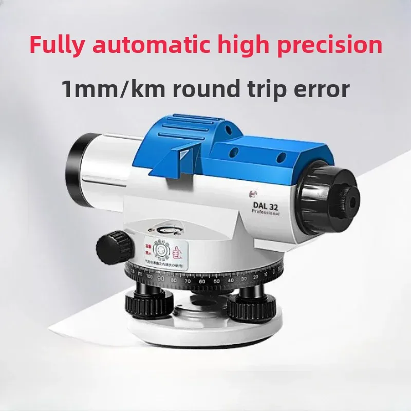
The 32/40 Times Automatic Leveling Laser Level is a high-precision leveling instrument designed for engineering measurement, surveying, and construction tasks. This laser level is equipped with automatic leveling technology, ensuring accurate and efficient measurements with high precision in a variety of outdoor environments.
With 32x or 40x magnification, it provides clear line-of-sight and fast leveling, making it ideal for construction site layout, land surveying, and alignment checks. The laser leveling technology ensures that the instrument remains accurate and stable even in challenging field conditions. The full set comes with everything you need for immediate use on-site, including a tripod, leveling rod, and carry case for easy transportation.
Key Features
-
✅ 32x/40x Magnification: Provides clear and precise line-of-sight for easy measurement and surveying, even over long distances.
-
✅ Automatic Leveling: Features automatic leveling technology for easy setup, ensuring that the instrument stays level even in uneven terrain.
-
✅ Laser Leveling Technology: Equipped with laser leveling, offering accurate and reliable horizontal leveling for site layout, construction alignment, and topographic surveys.
-
✅ High-Precision Measurements: Offers accurate readings for engineering measurement tasks with a high degree of accuracy.
-
✅ Rugged and Durable: Built with weather-resistant materials to withstand harsh outdoor conditions and ensure long-lasting durability.
-
✅ Portable and Easy Setup: Comes as a full set with tripod, leveling rod, and carry case, making it easy to transport and set up on-site.
-
✅ Wide Range of Applications: Suitable for engineering surveys, construction layout, land surveying, and alignment checks for infrastructure projects.
-
✅ Long Battery Life: Equipped with a long-lasting battery for continuous use during long-duration field tasks.
Technical Specifications
-
Model: 32/40 Times Automatic Leveling Laser Level
-
Magnification: 32x or 40x (depending on the model)
-
Leveling Type: Automatic leveling with laser technology for accurate horizontal alignment
-
Accuracy: ±2mm/1km (depending on the model)
-
Laser Type: Horizontal laser leveling for precise measurements
-
Display: Digital or analog display for easy reading of measurement data
-
Battery: Rechargeable battery for long hours of continuous use
-
Protection Rating: IP54 (dustproof and water-resistant), designed for outdoor field conditions
-
Weight: Approx. 1.5 – 2.5 kg (depending on the configuration)
-
Power Supply: 12V DC rechargeable battery
-
Operating Temperature: -10°C to 50°C, suitable for a wide range of field environments
-
Tripod Compatibility: Includes standard tripod mount for stable setup
Applications
-
Land Surveying: Ideal for boundary surveys, topographic surveys, and land development projects.
-
Construction Projects: Used for site layout, alignment, and measuring angles during construction of buildings, roads, and infrastructure.
-
Engineering Measurement: Suitable for construction alignment, precision leveling, and foundation work in engineering projects.
-
Geospatial Mapping: Ideal for geospatial data collection and terrain mapping for urban planning and land development.
-
Environmental Monitoring: Used for surveying environmental features, such as water bodies, terrain features, and natural landforms.
Summary
The 32/40 Times Automatic Leveling Laser Level is a high-precision instrument designed for engineering measurement, construction layout, and surveying tasks. Equipped with automatic leveling technology and laser leveling for precise horizontal alignment, it provides accurate and reliable measurements in harsh field conditions. The full set comes with all necessary accessories for easy transport and setup, making it a great tool for land surveying, site layout, and infrastructure development.


Related products


20PCS Laser Distance Meter Rangefinder Range Finder Build Measure Device Test Tool 40M/131ft/1575in


High Precision Optical Digital Collimator for Total Station Theodolite Auto Level Survey Instrument F550-1


